Monday, January 31, 2011

February 1 - Sanson to Levin - 93 km; Train to Wellington

It was clear and calm when we woke up, so we decided to ride and we left the motel at 0640.   We quickly passed yesterday's endpoint and made good progress to Foxton.  The landscape is flat, almost Manitoba (a few more trees).  Foxton is another little one main street town.  This is the first thing you notice as you enter town - the judge's tower on the local race track.  Many small towns have them.  The pubs all have one armed bandits and live TV betting on horses, dogs and who knows what else (if it moves you can bet on it?)


We're on the Foxton flats now - where the wind really blew yesterday.  We appreciated the calm today.  The highway is on the viaduct - expendable cyclists get the cycle track in the flood way.


We noticed there is competition in the "Poo" market (remember yesterday they wanted $5 for a bag of Sheep Poo).


And, another humourous photo.  Here's where Kye can stay on our next trip, but only if he pulls his sox up with the training, eh Rick?

Onward - we made it to Levin at 1030 (great progress) and stopped for a bite at Whispers, where the group ate on the previous NZ trip.  Then we pulled into a bike shop for route advice and spare brake pads (South Island coming up!) .


By 130 pm we made it to Paraparaumu, the furthest stop out on the Wellington commuter rail system.  $8 per person with no charge for bikes was too good to resist, so we hopped on the train.

Here's a view of the coastline from the train.  I was on the wrong side of the coach to get a shot of the harbour as we came into town.

Laura decided to treat me (treat herself?) so we are staying in the Holiday Inn for a couple of days.  I called down to Reception to ask them if I had to turn on the bathroom exhaust fan when I started my camp stove (well, not really).  (Ian, I forgot to mention I got a great little butane stove way back in Thames.)    

Tomorrow (maybe the next, also) is a tourist day, then off to the South Island.  My GPS says I've pedaled 976 km so far.

January 31 - Wanganui to Sanson - 56 km


Today started off well.  Cloudy but with a good tailwind.  The weather forecast was for drizzle, rain and high winds later on.

Rolling country again with not much in the way of hills.  I saw this immaculate pasture (probably better than some of the greens you putt in, eh, Pat).  It had a pile of sheep so I stopped for a photo and a chat.  Unfortunately, I spooked them and they stampeded (sheep-peded?)


We made great progress and stopped in Bulls for a break. Bulls was named after John Bull, who first arrived in 1859 and had the new town named after him in 1872.  It's basically a wide spot in the road with services and a bus depot.  Check out the play on words on the sign. The library is Read-a-bull and the pharmacy is Indispens-a-bull.

7 km down the road from Bulls we had to turn right at Sanson village onto a different highway.  Bad move!  Now the wind was at right angles and blowing as hard as can be (weather report had gusts 100  - 120 km).  Less than a km further along, Laura was blown right off the road.  We tried for a while longer, but then gave up and went back to Sanson.

So, here we are, in a nice motel in beautiful downtown Sanson.  I told you Bulls was only a wide spot in the road - Sanson is so small the "Welcome" and "Goodbye" messages are printed on the same sign.  

Talking to some of the locals, they told us that it would have been worse further along at the Foxton flats and we were wise to curtail the day.  Not a total loss - I did some bike maintenance.  

We tried to get Internet access, but the only place in town is the Library and it was only open for 2 hours this morning.  So, you'll see this sometime in the future.

Our options for tomorrow:
1. If the wind decreases we'll ride,
2. Go back to Bulls and get a bus to Wellington.  The only problem is that bicycles are allowed on the bus as the discretion of the driver.  It will depend on what kind of mood he's in.  

Stay tuned and we'll tell you what happened.  Meanwhile, maybe I can find a Cricket match on the telly.  This last photo sort of summs up the day.


Sunday, January 30, 2011

test

test post

January 30 - National Park Village to Wanganui - 124 km

After yesterday's torture test, what do we do?  Go farther of course!   Today's distance was 124 km, but with a lot of downhill as we left National Park Village (elevation 820 meters) and cycled to Wanganui on the coast.  Interestingly enough, even though the track was generally downhill, we still managed to climb 1005 meters throughout the day.  We spent 7 hours pedaling as opposed to 8 the day before.  We had cloud in the morning and no headwinds until mid afternoon, by which time we had completed about 75% of the distance and were working our way up the last 150 meter hill.


The countryside is very pretty, quite rolling with pastures and crops on the flat areas, and pastures and forests on the steeper areas.  We saw mostly sheep in the pastures.

The sheep are generally skittish - a semi-trailer can roll by and they ignore it, but if we sneak up on them and say "Hi" they often scoot away.


These falls are the largest we've seen so far.  I saw a photo of them in the paper, taken last week when they were in full flood.  A huge difference!


Here's where we had lunch at a bridge over the river.  Note all the palms along the side.  A beautiful spot.  I forgot to mention that there was very little traffic on the road, so the cycling was easy.


And here's a photo of me, proving I am in New Zealand, and not hiding out in Coombs.  They even named a road after me, but forgot the apostrophe.


So, we made it into Wanganui about 1600.  We had talked to a motorcyclist earlier on - he recommended the Grand Hotel, so we found it and stayed here.  It is showing its age, but is funky and we get breakfast thrown in.  They won't make any money off us, with our cyclist appetites.  I have to be  in the lobby to use their wireless Internet, but I can sit here with a beer, so  it is very civilized.


Check out the manager's vintage car out front.  It is a 1952 Singer Sport - he calls it a poor man's MG.


I gad an hour before dinner, so I rode around the downtown to have a look.  This roundabout seems to be the centre of downtown.


Tomorrow, Laura is planning on 100 km to a town called Levin.  She claims it is a flat road - we'll see!


January 29 - Taupo to National Park Village

To catch up on January 29:
So, I think I warned you about today's ride - it would be a challenge.  Well, it lived up to it.  108 kilometers, elevation gain of 1100 meters, 8 hours 'in the saddle' (pedaling), and a whole load of headwinds.  At the end of the day we were too bagged to do anything more than have dinner, watch a couple Overs of a crichet match (I'm a fanatic, eh) and hit the sack.

This first picture is of Lake Taupo as we pedalled around the shore.  Note the whitecaps - and at
this point the headwinds weren't too fearce.  I took this at a Holiday Park, hence the caravans.  I still say the lake shore resembles Penticton.


We're now fighting our way up the hills to Tongarira National Park.  I had mentioned the volcanic activity in the area.  In this photo the lighter gray material is a lava flow or ash deposit on top of the existing ground.


This shows the desolation of the area.  I understand that this is relatively young native vegetation on top of ash or lava.  This in in the Tongariria National Park, so I'm guessing it will be left to regrow naturally.  Unfortunately, we can see lots of invasive species - two prominent ones are Scotch Broom and Pampas Grass.

By the way, Laura planned this part of the trip so we could see the 3 mountains in the park that were used in the Lord of the Rings movies.  The bottom 1500 meters was all we saw.  Mount Tongarira is in the background of this photo (I was told).


This shot is the roadside vegetation.  In this case I think most of the species are native.

National Park Village was nothing spectacular.  It's of the "if you blink you will miss it" size.  There is a ski hill nearby, but most of the attraction in the summer is hiking on the 3 big volcanic mountains.  We stayed in a hostel here that was busy, so we got put into a 6 bed dorm.  Not so bad - everybody is getting up at 0530 or 0600 to go hiking, so we got up with them.  Luckily, nobody snored.
By the way, since we pedalled up there, we got the "carbon - friendly" rate, saving us a whole 6 bucks (NZ).  A lot of pedaling and sweat for that money!


Thursday, January 27, 2011

January 28 - Rotorua to Taupo - 82 km

 Hi, again:

A long, but easy ride today.  A 200 meter gentle climb out of the crater of Rotorua and then generally downhill and flat to Taupo.

We started off early - for those of you .who have been here before, the picture at left proves we were in the MacDonald's in Rotorua.  They have entire walls of Maori carvings.  A quick brekky of pancakes and off at 0730 before the heat gets us.


Along the road we passed various steam vents.  The whole of the central part of the north island is volcanic with a tectonic plate boundary directly beneath.  So, there are steam vents (we passed 6 or more today)  and the morning news often reports earthquakes.  We passed a power station today, but I don't know if it is geothermal (I suspect it is gas fed).


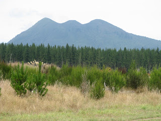
  The photo above is a group of inactive (probably not extinct) volcanoes north of Taupo.

Today, we had our first bike problem - I got a flat tire.  Actually, I think this is my first flat since Trois Riviere on our Canada trip in 2008.

Since we got an early start, we got into Taupo about 130 pm, so we only got some of the noon heat.

If you look at a map of New Zealand, there is a big lake in the centre of the North Island - Taupo is at the northern end.

My first impression of Taupo - Penticton!  It's a nice, touristy lake town.  As is typical, it is very clean and friendly.  On the lake front street, there are a lot of familiar signs - Pizza Hut, Burger King, Wendy;'s & McD's for example.


Except, Penticton doesn't have any of these - would you go for as pee in a Super Loo?"

Being a curious sort, I had to try it out, so I went for a coffee to give me an excuse to go.

It costs 40 cents, but you could also have a shower there.

Laura went off to scour shops, so I visited the museum (you don't think the Super Loo would be my only cultural foray in Taupo, did you?)

And, I had to take a picture if this, whatever the heck it is. I think I would hit the ditch if I saw this coming toward me.  Gypsy something or other, I guess.

Tomorrow is going to be a long day - 105 km to National Park with lots of uphill and possibly some rain and headwinds.  We'll give it our best shot.

Wednesday, January 26, 2011

January 27 - around Rotorua

As I mentioned yesterday, today is a free day around Rotorua, and we are playing tourist.  We also dropped into the bike shops to get some route advice.

Background - Rotorua Lake is a crater lake.  There is lots of steam activity still and as you walk around town you occasionaly get whiffs of sulphur smell - kinda like living in a pulp mill town except you can't blame a company.  Laura has looked at me sideways once or twice and asked if I'm responsible for the smell - I have plausible deniability!

Our main visit today was to Te Puia Cultural Centre for a tour of the geyser and pools and a Maori concert.  Their website is www.tepuia.com.   Here is a shot of the geyser when it is quiet.  It will shoot 90 feet when it erupts.


One of the bubbling mud pools.  Yesterday in town at the Maori village there, when I told the lady what we are doing she gave me a tube of Thermal Mud body rub, to releive aches and pains!


A view up the hill, showing how there are various vents and pools everywhere.  If you look carefully, you can see a couple of guys in visi-vests wandering around (sacrificing a maiden?).
I did take some videos of the volcanic activity with my camera - some of them came out not badly.  However, I can't upload them to the blog without using up my Internet account.  There is no such thing as free wireless 
here and you pay for Internet access by the megabyte.  Ouch!


Onto the Maori culture.  3 shots of the village.  Note the detail carving in the last shot.


 And the Maori dancers.  My camera didn't work well inside, so the photos aren't good.  The concert
was great.  I did some more videos which came out surprisingly well, except I shake a lot.

And check out the chief's reaction when Laura told him about our cycling rouite across NZ.


Back into town for a wander about.  This is the Spa building, built in 1908 as NZ's first major attempt at tourism. It's now a museum.  Beautiful building and immaculate grounds, including the lawn bowling greens and Croquet Pavillion and grounds.  They even had a BC totem, donated by of the tribes from Kingcome Inlet.

On the right is is a view of the lakefront, showing the results of all the activity.  I'm not sure I would pay big bucks for this lakefront.  Other parts of the lakeshore looked pretty normal.

Lastly, just for you Al - we saw this bike in one of the shops.  In case you can't read the tag it is $11,699.  

We would have bought you one, but I know you don't like red and they didn't have one in blue.

We're off to Taupo tomorrow.  Heavy rain is forecast for the weekend, but they think it will stay in the north (where we've been) so it should miss us.


Tuesday, January 25, 2011

January 26 - Tauranga to Rotorua - 63 km


We got going early and had bacon and eggs in Tauranga to prepare for the big climb into Rotorua today.  The weather has improved; clouds and sun, so sun screen was the order of the day.

For those of you complaining about only seeing pictures of Laura's backside, here's one of her frontside.  And, bonus, she's smiling (we're not to the Gorge yet).


This is Mangorewa Kaharoa Gorge.  Laura wouldn't be smiling if she was in this shot.  Actually, today's ride wasn't too bad.  We had to climb from just above sea level to 500 meters, with multiple additional hills.  Our total vertical climbing was 734 meters. Laura figures this climb was tougher than the one to Rotorua on her previous NZ cycle trip. 


This shot is our profile today.  The gorge is the notch at the top of the climb. We wore off some brake pad on that one. (Sorry, but I can't get the profiles any larger on this computer, due to the way my software works).

These are some swans at the lake in Rotorua.  Rotorua Lake is the remains of a volcanic crater filled with water.  Lake Taupo (south of here) is even larger.  We'll be there in a couple of days.  Tomorrow, we are staying here to play tourists.


The Anglican church on the lakefront.  Those who were on the previous NZ bike trip will recognize it.

This is our backpacker accomodation.  So far, we haven't been disappointed with any of the backpackers we've stayed at.  They've all been clean (this one especially) and reasonably comfortable, and about 1/2 price of our motel last night (which wasn't too expensive, either).  It's almost like getting dinner free!

Monday, January 24, 2011

January 25 - Waihi to Tauranga - 62 km

After a night in the pretty little Waihi Motor Camp we got up to cloudy skies and headed out, after
a goodie in town.  Fairly easy cycling - I don't mind clouds for cycling since it keeps the sun
off.

About half way through we stopped for bacon and eggs past Katikati.  Then the drizzle started,
making the cycling miserasble.  The road was easy with good shoulders.  The only place where I saw
my life go before my eyes was a 2 lane roundabout in Bethlehem (suburb of Tauranga).  One lane
roundabouts are a breeze, but a two laner with a lane change is scary on a bike.  We solved the
problem by walking the bikes over to the pedestrian crosswalk.

So, we are in a motel in the Summit Hill area of Tauranga.  Here's some photos:

-View of the Waihi Motor Camp.  Our (double bed sized) unit is half the little white building on the far left.  A really pretty place.


-A staute of a miner on the main street of Waihi.


-Part of the road past Katikati.  There are very tall hedges either side, I presume for use as wind breaks.  I think they were growing kiwis, grapes andother tree crops.

-A view of the waterfront in Tauranga.  I cycled around the residential part of downtown.

Tomorrow's weather is supposed to be better (still drizzle in the am).  Our destination is Rotorua Rua, which will require climbing a 500 meter vertical hill!  See you there (puff, puff!)

January 24 - Tairua to Waihi - 69 km

A more complete report on yesterday's action - back in the saddle after a day off.  A good day for biking - not a lot of sun, and mostly not too much wind.

-Last view of Tairau

We peddled down through Whangamata (the 'WH' is pronounced 'f', so its 'Fung-a-mata').  Its another small town on the Cormandel - the main street is one storey shops, the police station is smaller than our garage.  But plenty of character and an awesome steak and cheese pie.

Our typical day is yoghurt and bananas at the hostel, pack up and hit a bakery for a goodie and then hit the road.  We made it to Whangamata by 10 am, so we had an early lunch (the pie), stopped at the bike shop for route advice (and a free power bar) and headed on.  Another hill just before Waihi (235 meters) and the only down side to the day - the headwind was so strong we had to peddle downhill!

-See!  I told you it had rained around here!
We picked up some veggies and a jug of grape juice (!) and made dinner at the motor camp where we stayed.  No tenting yet because we were in a tiny little unit, which is just fine for us.

Waihi is a mining town with a huge open pit mine gold right in town, although you can't see it until you are right on the lip of the pit.  The mine opened in the early 1900's, closed in the 50's, and re-opened when gold prices went up in the 80's.  It, and a smaller underground operation are still going.  Later this century, when the pit shuts down, they intend to turn it into a lake.

More photos:
-Some sort of succulent plant in Whangamata


-View of the road from near the top of the day's last hill. We watched a fellow on a motorbike and a couple of dogs (Border Collies or Aussie Cattle Dogs) move a herd up the hill.  Fascinating to watch the dogs work.  Note the windy road.


-A view up the main street of Waihi.  Note what remains of the original headframe for the mine in the distance.

My GPS records a rather interesting statistic called "Total Ascent" which is the total of all the hills we have climbed in a day.  There were three two hundred meter hills on the route and a bunch of smaller hills.  In all, our total ascent was1006 meters, the first time on the trip we have broken the kilometer mark.  There are way more hills to go!