Tuesday, February 8, 2011

February 8 - westport to Greymouth - 102 km

An early start on a great morning.  It was clear and sunny, but cool, so full sun didn't bother us.  We got on the road shorty after 7, about 3/4 hour after sunrise.

Gently rolling countryside with 'nice' hills was the order of the day.

We made good progress and were inland for the first 30 km or so.  We saw this coal seam on the side of one of the hills.  I don't think it was good quality coal.


Here is one of our first views of the ocean.
And this is the hill we were climbing to get that ocean view.   It was actually not too steep.  We had 3 large hills today (100 - 200 meter climb each) but the gradients were not too steep - my guess would be 6 - 7 % (about Canadian highway standard)


 Penguin alert!  Shortly after seeing the sign, I caught this lady.  She was very unafraid, adn didn't seem inclined to fly.  It turned out she was a Bush Hen - the penguins aren't due in until April or May

On the insect front - I haven't mentioned cicadas yet, but we have heard lots of them, at times loud enough to be easily heard over any traffic.


here's a bunch more shots of the ocean.  You can see it was a spectacular day.


 The formation on the left are called the Pancake Rocks, a result of  sedimentary layers of limestone and other minerals.


Being ever vigilant, I found yet another vendor of Horse Poo.  Kara, Finn & Toby seem to have the best price, but there is some question as to the size of the bag. I wonder if there is a national stnadard size for an NZSHPB*


*New Zealand Standard Horse Poo Bag


On a sadder note - today we passed as close as we will to the site of the Pike River Mine disaster.  I was reminded of this when we passed a memorial for a 1967 mining accident at the Strongman Mine, where 19 miners died.


A couple of views of Greymouth, another town that sprang up in the mid 1800's after a gold strike.  The structure I am on is the floodway, built to keep the downtown protected from floods, of which there have been many.


Greymouth would be classified as a larger town, as it is big enough to have a MacDonald's.  The port looks pretty run down - I couldn't see any new docks.  There are a few fishing boat docks around.


Lastly, our current domicile, the Noah's Ark Backpackers.  We chose it not because of the name, but because the advertisement for it included a note about Bez, the Golden Retriever.  So we came here to get our Goldie fix.  Unfortunately, Bez is overweight.  

Noah's Ark was named because it was high enough up to survive the various floods they've had in this town.  Our room is on the upper floor, the left hand two windows.


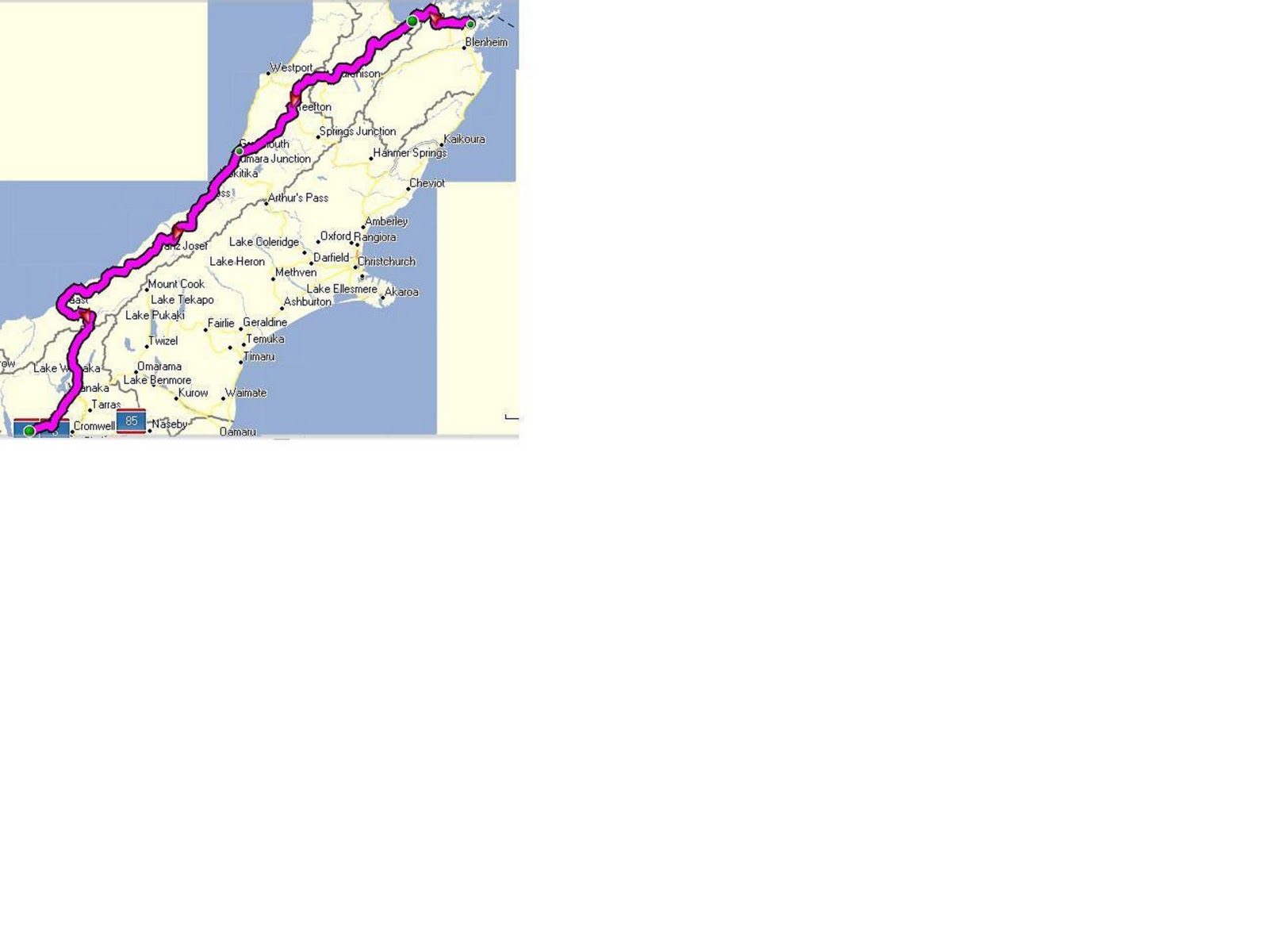
 We'll continue down the coast tomorrow.  Not too sure how far we'll make it after the great day we had today.  That will depend on the weather, but apparently the route is easy.

Sunday, February 6, 2011

February 7 - Around Westport

So, I told you we were taking a day off in Westport, and were we glad we did!  Drizzle turned to rain which turned to torrential downpour.  Then, in the afternoon it cleared up and the sun came out.

While it was raining I put a new tire on my back wheel.  I went through that tire in about a month, due to a combination of sharp aggregate on the road and me carrying a full load.  Both of our cycle computers were on the blink - I got mine working so I transferred it to Laura's bike.  My GPS is my cycling computer and is working great.  If anybody is going to tour NZ by any means and takes a GPS, talk to me about the "New Zealand Open GPS Project."  Free street maps with 95% of all businesses located on them.  A tremendous (free!) tool Laura found for me before we left.

Some words about Westport.  It was established after coal was found in the mid 1800's.  Dennistion (a short way inland) was the star project featuring a crazy inclined railway to deliver the coal to a railhead for shipment.  Lumber and fishing are also part of the local economy.  Here is the main street with a view of the municipal council offices - the tallest building in town.


 Our hostel.  It's 150 years old, beautiful inside (14 foot ceiling in the dining room) and very well kept.  And, it's still heated with coal!  Here's their coal pile (only I would take a picture of a coal bin, eh?).  Actually, somebody complained about the chill, so they started a fire today.


I hit the local museum first and then the beach after the sun came out.  So, here is my first beach photo - nice surf with some mountains in the background.  I stepped into the water - warm enough for swimming, but it looked like it might have a rip.  Apparently, the sand fleas can be bad with warnings about them in out travel book.  I saw a T-shirt in the Info Centre with the caption: "Sand Flea - the New Zealand bird of prey."  Hmmm....


Today's last photo is of part of the dock area.  They don't let the public on the jetties, so I couldn't get a great photo.  A lot of the jetties looked pretty rickety, so I was happy to stay off.  They were unloading tuna from a small fishing boat while I was there.

Back on the road tomorrow, heading for Greymouth about 100 km down the road.


Saturday, February 5, 2011

February 6 - Murchison to Westport - 98 km


Sunday morning and a slightly later start - after all we have a mere 97 km to bike today.

Here's the main street of Murchison - just before I took this shot there were 6 or more folks in there Sunday whites standing in front of the hotel, probably contemplating their washed out lawn bowling day.

Before I go any further the NZ Geography Police noted an error in my blog yesterday - it is the Buller River, not the Bulla River.  Oops.


Either way, it was raining in the Buller Gorge when we left, so we're just peddaling and not sightseeing.  About 20 km down the road the rain stopped.  Cloudy with no sun, wind or rain is just about ideal conditions so we made good progress.  Stopped at Inangahua for a bacon and egg pie and coffee.  15 km further we passed the Berlin Motel (only building for 15 kn either direction) - they were having a country music festival this weekend.  Kiwis imitating country didn't sound great, so we gave it a pass.

These are a couple of shots of the gorge.  Note the very thick and lush vegetation on the hills.  On the opposite side of the river there is a railway, but it is almost impossible to see.


Another interesting feature of NZ roads and this one in particular are a large amount of 1 lane bridges or culverts.  Most are small so you can see the other guy, but there are some larger ones.

This bridge across the Buller is one lane with signals at each end.  Bicyclists have a button to push.


This is scarier.  You can see they carved a one lane road out of the cliff face and put Yield signs at each end.  If you are on it first you win.  Ties go to people traveling south, based on the Yield signs at each end.  The system seems to work well enough - it teaches patience I guess.


The rain started again. but we made our target and are snuggled into the TripInn Backpackers in Westport.  It's actually a very nice large old home with additions.  We've bought food and wine for dinner.  No concerns about getting up early tomorrow because we are taking the day off.  I'll trip around town and give you the lowdown on beautiful downtown Westport tomorrow.  I also have to do some work on the bikes.

FYI, Monkey Bay Sauvignon Blanc costs $16 NZ (about $12 Cdn) here verses $15 Cdn in the BC LDB.


February 5 - Nelson to Murchison - 129 km


Another early start today to get a jump on the heat.  Here's a couple of pix on the way out of  Nelson.  The first shows the traffic infrastructure for cyclists.  Note how they create cycle lanes, paint them green at intersections and add markings.  All very civilized.


Here is the flip side - don't cycle here at high tide or you will be in trouble!.


We stopped at Wakefield for a hot chocolate and a goodie.  Just beyond we saw our first South Island vineyard (Penticton, eh?) and this derelict house.


Today's ride is our longest day yet.  It was supposed to be easier than yesterday with two long climbs and one short steep one.  We did the first hill with a Kiwi who has been cycling around NZ for the last 5 weeks and many times previously.  In his estimation the hills on the North Island are steeper than those on the South.  Welcome news!  Let's hope its true.


A couple more humourous shots.  Keeping track of the Poo market, this place sells it for a dollar a bag.  A huge discount!


And check out this statue - recycling at its finest.


The sun came out on our second hill and made the rest of the day quite brutal.  We climbout out of one valley and into the Bulla River valley heading for the coast.  The scenery in the Bulla River valley is quite spectacular, and the river is apparently quite famous for fishing.

After numerous breaks and a lot of water consumed we made it into Murchison and got a room at the 

Lazy Cow Backpackers.  It shows you the power of a catchy name - I chose it because the name jumped 
out at me when I looked up accommodation on  my GPS.  Marvellous device - I can roll into town and with a few clicks get a list of accommodation in town and directions to them.  

Tomorrow, it's off to the coast at Westport.  Not as long a day and we are taking the next one off as well!

Friday, February 4, 2011

Feb 4 - Picton to Nelson - 109 km

Another early start - we left the Villa Backpackers just after 7 am, grabbed a goodie and coffee at the bakery next door and headed out.  We climbed a hill out of Picton on the scenic Queen Charlotte drive.  Below are views of a ferry (not the one we came on) and of some twists and turns in the road.  It was a twisty one, no shoulders, no traffic but not too steep (about 6%).

Another photo along the road, of some palms along side.  The  vegetation is lush, but the soil seems fragile and easily damaged.  We saw a lot of 'slips' (small landslides) caused by all the recent rain.  And. I couldn't resist adding another picture in the Silly Signs department.

My last photo of Queen Charlotte Sound.  There are boats everywhere, and we saw kayaks and kayak tours as well.  It is sort of blasphemy to come all this way and not go for a sail or paddle, but that's the way it goes.

We left QC sound and headed inland for a while on very flat terrain - back into farming in the valleys and logging on the hills.   Crossing to the next inlet we stopped for a goody in Havelock (the green shelled mussel capital of the world) and continued on.  It was cloudy all morning which made for pleasant cycling, then the sun came out for our last two large climbs of the day.  It was full sun, no shade, and hot pavement for the last 3 hours so we got fried.  However, we made it to Nelson.  I didn't take any photos on the way into town.

After we got settled in a motel (the Backpackers was full) and we had our showers (very necessary!) I popped out for steaks, Greek Salad fixings and beer for dinner in the motel.  Great.  After dinner I cycled around Nelson to have a look.  Nelson seems like a newer town than many.  The industries here are fishing (I saw lots of boats & ice plants), mussel farming (I believe), forestry (from the looks of the hillsides and a local log sort) and freight, judging by the docks and cranes.
These are the steps to the Anglican Cathedral.  One of the fellows in the picture (drinking a beer) offered to do a Haka (Maori war dance) for 5 bucks, but I told him the crowd reading this blog would probably rather see a moon instead.  He declined.
Here's a shot looking back into town from the waterfront.  Note how he houses are spreading up the hills, ala Vancouver.
And last, but not least, for Lisbeth who said the photos of Queen Charlotte Sound from the ferry look so much like BC I haven't proved I'm in NZ.  So, here you go - a picture from the local shipyard.  Note that it contains a palm tree and in the background is a vessel named the "Cape Breton."  so, I'm either in NZ or they have palm trees at the shipyards in Nova Scotia (in February)!


Bye for now - we may be offline for a couple of days as we are heading toward Murchison, but may have to stop at a bicyclist's hostel partway there.  It is supposed to be hot tomorrow.
PS - Pat, I'll work on the picture of my butt.

Wednesday, February 2, 2011

February 3 - Wellington to Picton - Ferry

We were booked on the 10:25 ferry and, as per our usual style, we were ready way too early.  So, we stopped for breakfast at the railway station.  The trains arrive at a furious rate and there are masses and masses of people using the system, demonstratibg how a well run transportation system can work.

After breakfast we cycled the Wellington Waterfront Walkway/Cycleway.  That killed an hour and we were still way early for the ferry.   Her's looking back at the city from the walkway.


The ferry is a combination railcar, freight, vehicle and passenger (oh yeah, bikes, too if you pay

$15 each).  The ferry stern loads with the larger trucks backing on or off and cars doing a loop
around the bow.  Also, there are tie downs for all trailers, similar to the Newfoundland ferry we took a couple of years ago.  Heading out of Wellington harbour was slightly bouncy due to waves funneling through the harbour entrance.  After that sailing across Cook Strait was calm (but you can see a few queasy people on board).  I saw a photo of one particularly
 harsh  voyage - lucky we weren't on that one.  Only half the 4 hour voyage is on open water - we've just entered Queen Charlotte Sound (go figure on the name).  It's the NZ equivalent of going through Active Pass (but wider) so I'm going to stop writing and check out the view.

Here's a couple of shots of the sound from the boat.  Beautiful scenery, but if you squinted you could believe its Active Pass.


We sai8led into Picton and got off.  I was actually surprized at how quickly the ferry did turn around - not as fast as BC Ferries, but much faster than the Newfoundland or PEI ferries.  I'll say it again - our ferries are well run and reasonable cost when you compare to the other services we've seen.


Pickton turned out to be bigger than we thought which makes sense considering there are two ferry companies and a railroad in town.  Add that to the tourism and the services required and you get a good employment base.  Here's a couple of shots of Picton, of the main street and from up on a hill nearby.
 Being silly, I jumped on the bike and went for a short  ride up the coast (heading up the middle of this picture on the left).  Again, houses are perched on the hill precariously.  Many have roads to a group of them marked "Private Road - No Turnaround."  If some looky-loo in an RV went up there he would never make it out.


A last photo of the sound, from as far as I got.  I realized I haven't yet gone for a swim , yet.  (Don't worry, I have had a bath or two).  I'll have to jump in somewhere down the coast.


We're off to Nelson tomorrow.  It's 109 km on a very twisty road but not too hard, apparently.  We met another Canadian from Toronto who told us it was a piece of cake compared with some of the stuff we've already done.

Speaking of cyclists - we've met a dozen or more so far, most of whom have been in NZ about as long as we have been.  The largest number have been Canadian, one Brit, a few German or Swiss and a couple of NZ types.  Very few Americans.

By the way, we've been watching the news about the cyclone that hit Queensland today.  It came ashore as a place called Mission Beach, south of Cairns.  We stayed there on our first trip to Australia.


February 2 - Around Wellington

A day off to play tourist and do some chores.  Cloudy and windy - a good day to not be pedaling against the wind.  I got up early and walked around the parliament buildings - a lot of their buildings are from the era between 1880 and 1910.  What really impressed me was how packed and dense the inner city is.  Tall (10 story) buildngs in a real hodge podge of streets - nothing laid out in squares in this town.

After breakfast we toured bike shops to buy a helmet mirror (Laura broke hers) and to poke.  Then we parted ways as Laura went shopping and got her hair cut (it looks great - styled so as to avoid 'helmet head').


So, here are some of my tourist photos:
The cable car up to the Botanical Gardens, of course.


The second photo is of one of the original cable cars.  Note how you can sit outside on angled seats.  I poked through the cable car museum - great stuff for an engineer to look at.


These shots in the Botanical Gardens are of the threatened Species Garden and of the Rose Garden
with the greenhouses behind.


Here's a view of houses on the hill - it really shows how they've fit them onto the hill on the steep slopes.


Back to the top of the hill and a picture of the original Dominion Obsdervatory.  The gun in front wasn't for harbour defense; it was a captured WW1 German cannon given to New Zealand as a gift.


Downtown now and a shot of the original NZ Bank building; now a shopping arcade - typical architecture of the older downtown buildings.

On my way to the museum in the afternoon I noticed somebody had dumped a box of detergent into a local fountain - foam everywhere.  There are pranksters (UBC Engineers?) all over the world.

My last visit waas to the the Te Papa museum.  It's free (as were all the attractions I visited today).  Tremendously interesting place - the main impressions I got were of the amount of volcanic activity in New Zealand and of the concern over the number of introduced species into the country and the effect on the land.  Unfortunately, photography wasn't allowed.

We chowed down on a great pub meal tonight, starting with NZ Green Lipped Mussels.  

Tomorrow we're off to the South Island on the ferry and will probably stay in Picton.  This is our proposed route from Picton to Queenstown.  We'll see how it goes - we may cut across early to avoid the west coast weather.